520 Bridge turns 50 years old

Image: PEMCO Webster & Stevens Collection, MOHAI

Image: PEMCO Webster & Stevens Collection, MOHAI

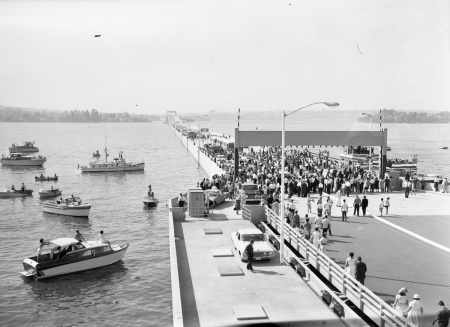
Happy birthday ol’ floater! The 520 Bridge opened 50 years ago today — August 28, 1963. On the same day that local dignitaries gathered for a ribbon cutting ceremony on Lake Washington, Martin Luther King led millions in the March on Washington in DC. Unrelated facts? Not in the least.

But before getting to that, WSDOT has been celebrating 50 years of floating across State Route 520 by collecting stories about the highway. Their “520at50 Memory Lane” website and Twitter campaign allows people to write their own bits of local history:

My friends and I rode our bikes from our Ravenna homes to be a part of the festivities. We got there well before the crowds arrived and stationed ourselves in position to see the cutting close up… I do remember that my friends and I broke the ribbons before they were cut and we held them together until after the official cutting took place. Each of us had a bit of those pieces of plastic in our pockets as we rode our bikes back home that day. — David Oehler

… when my girlfriends mom let me user her Vespa scooter while my car was being repaired. I would then drive across the bridge, under construction on the Vespa. The first time the construction guys said I couldn’t go but I told them I had to get to class after visiting my girlfriend. They recognized a true romance in the making and let me cross every day for about a month until the bridge opened when I had to pay tolls like everyone else, 25 cents. — Chris Warner

Looking back, we joke that our early years at Seward School dealing with constant SR 520 and I-5 construction noise is the reason we were stunted intellectually. — Anonymous

The site has a bunch of historical photos, documents and vintage video showing the bridge under construction in the early 60s. The silent footage is worth watching for scenes of workers throwing hot rivets, burning tree stumps (is that the Arboretum?) and a cable safety gate stopping a charging dump truck before the drawspan. The gate wins. Sort of.

WSDOT has also published a more substantial history website of the corridor as part of the 520 highway replacement project: 520history.org. The site, developed in partnership with HistoryLink, broadly covers the tribes that once lived between Portage and Union Bays, the industrialization of Lake Washington and tells the more “official” history of the 1960s floating bridge construction. Lots of interesting new material there.

As commendable as these efforts to record history are, there are many stones left unturned. While there is mention of the freeway politics behind the Montlake-Medina route choice for 520 over Kirkland-Sandpoint — (Montlake’s wetlands and garbage dumps were easier obstacles to overcome) — there is nothing about the discourse of those debates including “white flight” fears of diminished property values and “social change.” And most glaringly missing from the story: the grass-roots citizens’ protest that later defeated 520’s planned successor, the R.H. Thomson Expressway through the Arboretum and Central District. Eugene Smith’s 2004 book Montlake: An Urban Eden touches on this, noting how Seattle Mayor Gordon Clinton framed the city’s preferred Thomson route:

[Clinton] wrote Senator Warren Magnuson in November, 1960, to … “preserve the Arboretum as a priceless asset to the City and the State.” He acknowledged that condemnation of private property was necessary and that it would cost half a million dollars more than Plan A, as determined by city-appointed appraisers. Their report had observed that, if the right-of-way left the homes on the east side of 26th Avenue, “the present owners will tend to move elsewhere . . . [and] their replacements are apt, and almost certain, to be of a lower social stratum and will drop the quality and, hence, the value of the whole Montlake Peninsula.” Plan B, on the other hand, would produce a “very minor reduction of values in the total Montlake Peninsula [and] would more than offset the added cost of the private property acquisition.”

With Plan B, the city then demolished about a dozen homes on 26th Ave E. Hard to imagine that happening today.

Anyways — happy birthday, Bridge!

Breed Specific Regulations advocates respond to recent pit bull comments

After two attacks involving pit bulls in Montlake earlier this year, animal control advocates from Sudden, Random, Unprovoked & Violent (SRUV) have responded to reader comments from the initial story and a follow-up post from one of the dog owners involved. SRUV covers dog attack incidents across the country and argues for Breed Specific Regulations. Here’s their letter:

We’ve read with interest the posts about the recent pit bull attacks in Montlake, and the numerous comments which accompanied the posts. We would like to correct some of the misinformation.
SRUV is an animal welfare blog with an international audience. We have a special interest in pit bulls and advocate for stronger public safety legislation in the form of Breed Specific Legislation (BSL). BSL can include microchipping for identification, mandated spay/neutering, or insurance requirements. Over 500 communities in the country currently protect their citizens and more vulnerable animal companions with BSL, and more are adopting some form of BSL each year.
Pit bull attacks like the one in Montlake occur on a daily basis throughout the country. In 2013 there have been twelve fatal dog attacks, and eleven of those have been by pit bulls. Pit bull attacks which result in serious disfigurement or the loss of a limb occur at the rate of nearly one a day. Attacks on our animal companions are estimated to occur at a rate of 10x the attacks on humans. Sadly, the comments of the owners and advocates of pit bulls are as predictable as the attacks themselves. The comments under the Montlaker pit bull articles echo those we’ve read hundreds of times before. We’ve listed a few of those comments below, with our comments.
“The dogs did not intentionally bite this man. He got in between the fighting dogs, which is foolish and dangerous. This is common knowledge.”
  • This comment assumes that two dogs are fighting, rather than one dog attacking the other. It also blames the human companion, a victim of the attack, for his injuries,
“Poodles are more likely to bit their owners and people than pit bulls are.”
  • This same commenter goes on to mention Chihuahuas and labs are known to bite. This is one of the most commen arguments of pit bull advocates. While it may be true that Chihuahuas bite, they have yet to kill a person. The important point to consider is the actuarial value of pit bull bites, which are astronomically higher. Comparing Chihuahua bites to the bites of a pit bull is an outrage to reason. For additional information contact SRUV.
“Any animal can attack, any dog can bite”
  • This is a horrible way to excuse the attack on the gentleman and his dog. This argument reached its most ridiculous height with the phraseAny dog is capable of any act at any time, which was coined by a pit bull advocacy group from the UK.  The implication is that Yorkshire Terriers are as dangerous as pit bulls.
“Pit bulls are the most abused and mistreated dog in our country”
  • Wrong. Pit bulls enjoy the biggest, most professional advocacy campaign in the country, with staff attorneys, media representatives, and public relations gurus.
“and the stats of people being attacked are almost all dogs who have been abused, unsocialized, and raised as attack/ fighting dogs.”
  • Wrong again. Over half of the people killed by pit bulls this year have been killed by their own, much loved family pit bulls.
These comments are all from the initial article; the comments under the second article degenerate into name calling (ignorant, hater, etc), all of which come from those who advocate for the pit bulls. The exchanges under these articles demonstrate why pit bulls are this country’s next intractable problem, like gun ownership, gay rights, abortion, and immigration were. The advocates are guided  by faith and emotion, and are fervent in their beliefsystems. There are many reasons why we are currently in the position we are, but this forum is not the place to address that question.

The SRUV authors have requested anonymity out of concern for “safety and peace of mind.”

Montlake Bicycle Shop: Dems’ proposed bike tax based on false premise, hurts local businesses

By Neil Wechsler, owner of Montlake Bicycle Shop

A part of a 9.8 billion dollar transportation plan put forth by Democratic Washington State legislators is to create a new $25 tax on bicycles priced $500 and over.  As the owner of the Montlake Bicycle Shop, I am very concerned.

My main points of objection are:

1.      That it is based on the false premise that the roads, highways and bridges are paid for primarily by gas and motor vehicle taxes.  My research has found that the majority of the cost is borne by the general fund that all taxpayers contribute to.  Bicyclists are already paying for the roads, even the few people that never buy a gallon of gasoline.  If we drove cars instead of riding bikes it would cost taxpayers more, not less.

2.      This sounds preposterous but I spoke to a legislative aide who confirmed that it is true: If this passes the tax would be due only on sales from local bicycle stores.  People buying bicycles from out of state who are already not paying our 9.5% sales tax would not have to pay this tax either.  On a $500 bike this would amount to a total of about 14.5% in taxes that we would have to charge.

3.      When you raise the price of a product sales are certain to go down. Some people will find an untaxed out of state source, some will buy a lower quality bicycle, and a few may not buy a bike at all.  That will end up meaning less employment in bike shops in our state.  In the last campaign it seemed like every candidate was running on a pro-jobs platform, yet some of them are now suggesting we create a new burden on local small employers is being proposed for invalid “symbolic reasons.”

4.      That the tax, which is projected to bring in only $100,000 in revenue per year may well cost the state more than that amount.  Creating, collecting, and enforcing another tax is expensive.  If you include that some sales would be driven out of state the lost sales tax revenue would pretty much assure that the fee would end up costing the state money.

Please consider resisting this proposal by writing or calling our legislators, Frank Chopp and Jamie Pedersen.

Further reading:

Inslee to consider new candidates for State Secretary of Transportation

WSDOT Secretary Paula Hammond (left) and Sound Transit CEO Joni Earl. Image: Flickr/Oran Viriyincy

The Tacoma News Tribune reports Governor elect Jay Inslee has begun a national candidate search for top level cabinet positions including Secretary of Transportation. Current WSDOT Secretary Paula Hammond has expressed interest in staying on and will be considered for the job among a new crop of transportation leaders.

Transportation Issues Daily speculates on the field of candidates, mentioning names both familiar and unfamiliar:

Rumor has it that one possible candidate of interest to the Inslee transition team, Joni Earl, has re-upped with Sound Transit…

Former state Representative Mike Armstrong is interested in the job, as detailed by Brad Shannon and Jordan Schrader of the Olympian. Another name that might surface is Carlos Braceros, Deputy Secretary of the Utah DOT. He supposedly was a top-shelf candidate when Hammond got the job. Braceros has helped UDOT become a leader in public private partnership projects and many other areas.

Consideration for WSDOT Secretary comes at a critical time for Montlake. The State is busy planning the Seattle SR-520 replacement project so that it is shovel ready when the $1.4 billion funding gap is secured — likely through a transportation package (promised during Inslee’s campaign) or by tolling I-90 (starting in 2016). Or both. The leader of WSDOT under Inslee will oversee the completion of the 520 megaproject, the first urban freeway built through a Seattle neighborhood in a generation.

Paula Hammond’s stewardship of the 520 project has been mixed. Recent praise for the 2012 Seattle Community Design Process has restored some faith for many who were dismayed by the State’s preferred alternative selection in 2011. Hammond’s leadership in creating a State bicycle-pedestrian plan should also be applauded, along with the regional trail on the new floating bridge.

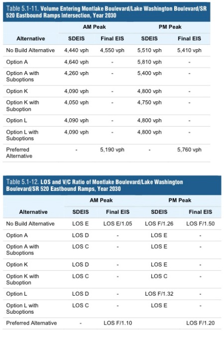
However, as public feedback overwhelmingly pointed out during the 520 design process, the bicycle and pedestrian access around and over the new freeway is sorely lacking. Many, including this blog, feel the design makes walking and biking over 520 worse than it is today. As well, Montlake leaders working with the State during its consideration of replacement options were stunned to see WSDOT choose a preferred alternative that increases traffic congestion on Montlake Blvd. This legacy, now written into the State’s Final EIS, shows the new 520 will (at best) maintain traffic gridlock on Montlake Blvd:

Traffic conditions for the 520 preferred alternative vs other options. Image: SR-520 Final EIS, Section 5.1, page 41.

Projected traffic conditions for the preferred alternative at Montlake Blvd & Lake Washington Blvd versus other design options. The top table compares vehicles per hour (vph); the bottom table compares “LOS” (Level of Service, transportation speak for an A-F grading system). SR-520 Final EIS, Section 5.1, page 41 (2011).

That a $4+ billion highway replacement creates an “LOS F” for traffic on Montlake Blvd is a bitter pill for residents and commuters alike. That’s a lot of money to spend to only achieve a traffic failure. Furthermore, expecting bikes and pedestrians to fend for themselves in this mess was not a decision made on the watch of a progressive transportation leader.

Larry Ehl (Transportation Issues Daily editor), recently wrote on Crosscut for Inslee to keep Hammond as WSDOT Secretary. Among her accomplishments, Ehl (a former Hammond staffer) praises her as a nuts-and-bolts leader, adept in behind the scenes bureaucratic battles. Hammond’s recent Seattle Times editorial on maintaining the infrastructure we have speaks to these qualities. Ehl also counters Seattle Transit Blog’s call for more progressive leadership at WSDOT, arguing the agency’s legislative limits makes life difficult for “change-agents” like Hammond.

“Change-agents” aside, public attitudes toward building freeways through urban neighborhoods changed 5o years ago — and here we are today facing a new freeway, double in size, and reminiscent of the car-first 1960s. Inexplicably, its “landscaped lids” are used as off-ramps and its regional trail across the floating bridge doesn’t continue over Portage Bay to I-5, Eastlake and the booming Amazon campus in SLU. While there are positive signs that more attention will be given to people-first aspects as 520 design work continues in 2013, this effort is largely community driven and not directed from internal leadership at WSDOT.

Hammond’s influence over the 520 project has yet to bring positive change to the traffic-choked Montlake neighborhood. Whether or not the job position allows for such change is debatable. Hopefully Governor-elect Inslee’s progressive pedigree will give the next Transportation Secretary more leeway to build highways for people, not just cars.

Sound Transit to study light rail on 520?

Seattle Transit Blog reports that Sound Transit is set to spend $9.76 million in 2013 to study new light rail lines for their long range plans. While not yet confirmed, Sound Transit staff say three corridors will be studied as part of “ST3”, including a line from Ballard to UW to Kirkland with options for continuing to Redmond, Bellevue or Issaquah. Presumably, crossing Lake Washington via the new 520 Bridge would be part of the study, an idea that would have significant impacts for Montlake.

To review, the current design for the new floating bridge is “light rail ready.” That means with additional pontoons attached to its sides, trains can claim the center HOV lanes — or — an additional two lanes can be built to effectively make an 8-lane bridge. That’s the easy part.

The hard part is getting the trains between the floating bridge and UW Station. A tunnel would have to transition through water — not an easy nor inexpensive proposition. An above ground solution would have to bridge over the Montlake Cut only to arrive at UW on the surface, leaving no good options to go from there. So then, how to tunnel through and then under Union Bay?

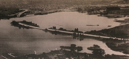
A similar idea was once planned for the never-built R.H. Thomson Expressway, as part of its interchange with SR-520 (seen at the end of this post) in the 1960s. The plan was for a vehicle tunnel under Union Bay via a massive, man-made berm:

20121219-233954.jpg

Images from: Roy W. Morse, Worthington Christiani Fenco, 1967.

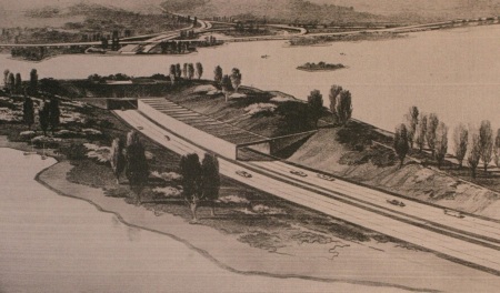
Yes, that is an artificial peninsula with a trench leading to a submerged tunnel under the shipping channel (note Husky Stadium in the upper right). Here’s a closer view:

20121219-234848.jpg

A man-made berm, trench and submerged tunnel under Union Bay, proposed for the ill-fated R.H. Thomson Expressway. Arboretum 520 ramps in background.

Hard to imagine these days, but apparently this was possible before there was, you know, an environment (and irony) to consider. Are we prepared to do something similar to run light rail over 520? Got a better way to get Eastside light rail to UW Station?

As Seattle Transit Blog notes, Sound Transit is moving forward with this study because Seattle keeps making noises about funding and building its own in-city light rail. ST wants to preempt the go-it-alone strategy for fear it would then loose Seattle’s tax-happy appetite for regional light rail (e.g. to Issaquah). So then, if buses using 520’s HOV lanes can get to Microsoft just as fast as light rail, is it worth the expense and possible environmental disruption to run rail through Union Bay? With Sound Transit having to balance its regional mandate, don’t be surprised if they answer “yes.”

For more on the new light rail studies, see the STB post here. See also this Slog post from 2010, and its drawing of a light rail route using the Montlake Lid and a second bascule bridge to reach UW Station. This is a non-starter, not necessarily because the City delayed the bascule bridge “for the foreseeable future,” but because it uses NE Pacific Street, which UW will never allow.

New HistoryLink article details economic, cultural impacts of the Montlake Cut

20121217-091705.jpg

The Montlake Cut, sometime between 1916 and 1925. Image: unknown print.

A new HistoryLink article on the Montlake Cut dives into the marshy beginnings of the Lake Washington Ship Canal, arguing the Montlake isthmus was ground zero in reversing the natural drainage of the Cedar-Duwamish River basin in the name of economic prosperity.

The article also discusses the human and environmental costs of building the canal and is a great read for its many wonderful details — Montlake’s native place name, Swa’tsugwlL translates to “carry a canoe” — the coal trains that preceded the canal — the Chinese labor that dug the first ditch — an Army Captain’s blind eye to lawsuits as he blew up earthen dams holding back Lake Washington — The Seattle Times boasting in 1917 that “every thinking person” knew the Ship Canal would bring Seattle “undisputed Pacific Coast supremacy.”

While the article focuses on the Montlake Cut’s economic intentions, it notes that industrial “supremacy” never really came (Boeing at Renton and the Navy at Sand Point notwithstanding) and instead it gave the city recreational benefits. There is more to this point: the Cut, in moving people and goods between ‘monts’ and lakes, connected people to the landscape of Lake Washington in a powerful way, through recreation, which helped shape Seattle’s contemporary environmental values. Shoreline parks, wetland lagoons, boating, Seafair — even Montlake’s later right-of-way for a floating freeway — all connected people to Seattle’s landscape of mountains, water and weather.

In connecting this history to the present, it’s clear that Montlake is still very much a place to “carry a canoe,” whether that canoe is a UW rental, a bicycle, the 545 bus or a Seattle-standard-issue silver Toyota Prius. And with big new infrastructure projects underway — light rail, 520, a possible second bascule bridge, and the planners of each now selling environmental as well as economic benefits — one wonders what unintentional consequences these projects will bring next.

Montlake Cut (Seattle) — HistoryLink.org Eassay #10221 — by Jennifer Ott

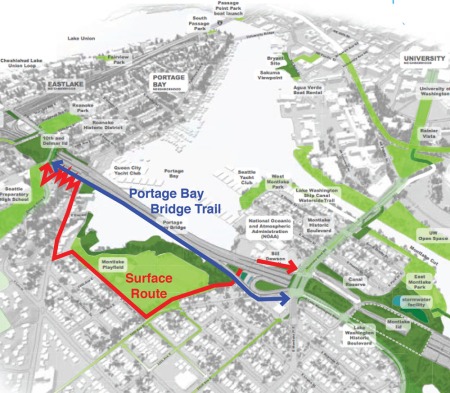
Portage Bay Bridge Trail vs Surface Route tests will for minimum freeway width

Two possibilities for bridging pedestrians and bicycles between Capitol Hill & Montlake. Image: Montlaker via WSDOT

Two possibilities for ‘bridging’ pedestrians and bicycles between Capitol Hill & Montlake. Image: Montlaker via WSDOT

All has been quiet in 520 design news since WSDOT presented public comments to the Seattle City Council on November 26th. One issue getting a bit of attention is the Portage Bay Bridge width given the show of overwhelming public support during the public comment period for adding 14-foot trail. For years residents have lobbied for minimum freeway width to protect the natural environment of the 520 corridor. This year WSDOT published design drawings showing what the new 520 will look like from the bicycle and pedestrian point of view — and suddenly the debate changed.

Central Seattle Greenways supports using 520’s Portage Bay Bridge as a direct and easy-grade route up Capitol Hill. A recent blog post, Bridging the Topographic Fortress with a Trail, compares a Portage Bay Bridge Trail to alternative surface routes up and down the ‘fortress’ with the hard data of distance and grade. Really though, it’s a bit of a no-brainer: cycle up the Portage Bay Bridge (4.5% grade) — or — ride underneath 520, around Montlake Playfield, along the Boyer Ave arterial, then up a new trail through the Roanoke underbridge area that includes a dozen switchbacks to reach Delmar?

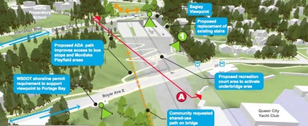
Image: WSDOT

Image: WSDOT

Flattening the steep grade between Seattle’s densest neighborhood (Capitol Hill), booming tech district (South Lake Union) and academic research center (UW) would go a long ways toward meeting the City’s goals for increasing bicycle use in the name of sustainability. And yet, the sustainability cause underpins the minimum bridge width demand as well. Or at least it did back when the 520 debate focused on numbers of vehicle lanes. So who bears the sustainability standard now? Minimal freeway footprint or 75 years of easy walking and biking up Capitol Hill?

Central Seattle Greenways’ Topographic Fortress offers ideas on having it both ways:

Even though the vast majority of community members and groups (including the Montlake Community Club and the Capitol Hill Community Council) support a Portage Bay Bridge Trail regardless of how the bridge is built, there is still interest in making the bridge as narrow as it can be without sacrificing its utility. Here are a few ideas that have been floating around:

  • Use steel rather than concrete for the bridge – this allows the bridge to have less visual bulk
  • Remove the planted median from the middle of the bridge
  • Reduce any unnecessary gusset space (the concrete webbing between lanes)
  • Decrease the lane width – the bridge is slated to be restricted to 45 mph, meaning that lanes can be an urban width rather than suburban freeway sized.
  • Finally it may be worth considering how hanging the Portage Bay Bridge Trail in different manners (underneath, partially offset, raised, etc) affects the light situation.

The first and last ideas likely have the most merit, as WSDOT claims to have done all it can to minimize the PBB width. While WSDOT should always be encouraged to sharpen its pencil, in the end, freeways are political products. And here are the democratic politics of the public comment period:

Support to include a 14-foot regional shared-use path on the Portage Bay Bridge. (Approximately 1,298 of 1,339 individual comments support this preference.)

So it seems the Seattle public is willing to add width to the bridge for the right reason — in this case, using your own two feet to walk or bike along 520.

Could an urban gondola solve the Montlake Mess?

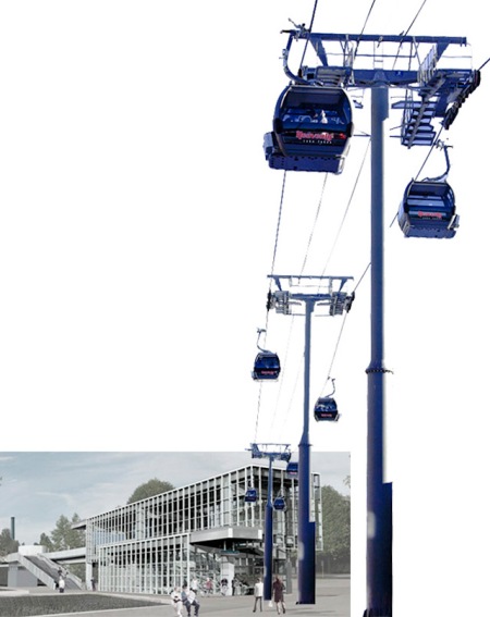
Image: Sound Transit + Flickr: Selbe B

Image: Sound Transit + Flickr: Selbe B

Light rail in the far corner of campus — the 520 flyer stop a long walk from nowhere — lumbering buses merging left, blocking traffic — bus stops located far from UW Station. If transit is going to be a solution for the Montlake Mess, this tangled knot of bad connections will have to be untied. How to better move buses through Montlake? Don’t. Use an urban gondola instead.

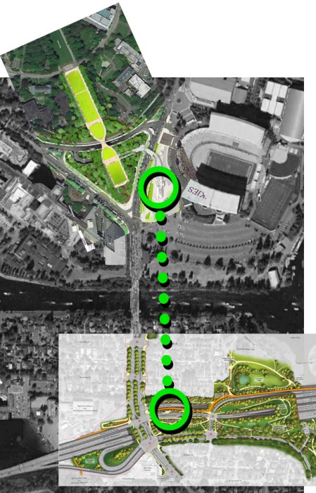
A gondola could easily connect the 520 flyer stop on the future Montlake Lid to light rail at UW Station with door-to-door service. Imagine stepping off a 520 bus at Montlake, stepping onto a gondola car, riding it for two minutes over the Montlake Cut and arriving on the upper level of UW Station. An escalator/elevator ride down takes you to light rail below, or walk straight across the pedestrian bridge toward central campus.

Gondola lifts are proven people movers. They safely and comfortably travel over mountainous ski terrain the world over — and they’re increasingly being used in urban environments. London has one over the Thames. Medellin, Colombia has one. Portland has a cable car. St. Louis, Austin, and Chicago have considered them. Earlier this year, one was even proposed for South Lake Union.

But this isn’t just fantasy — it makes sense for Montlake. UW Station is about 1800 feet due north of the 520 flyer stop. That’s enough distance to discourage bus riders from walking — but it’s a modest distance for a gondola. A gondola’s cable system could easily sail over the clearance needed for tall ships in the Montlake Cut and it would be a lot less intrusive than a second bascule bridge. It’s the easiest way to move lots of people over difficult terrain.

How do gondolas compare as transit? Crystal Mountain ski area recently built a 1.3 mile gondola for around $6.5 million that carries up to 450 people per hour (900 with more cars added). The 1.3 mile South Lake Union streetcar cost $56 million and now carries about 2,500 people per day. Comparing capacity and ridership are apples and oranges, but the two systems are in the same ballpark — with the gondola costing a fraction of the price.

So rather than run routes over the Montlake bridge, buses could drop riders at a transit hub on the Montlake Lid, right in front of a gondola station with cars arriving every 30 seconds. Each car can carry a dozen or more people, moving an entire bus load to UW Station in a matter of minutes. What’s the actual transit ridership through Montlake? A recent Nelson/Nygaard study found 11,000 transit passengers cross the Montlake Bridge each day on some 600 buses. Thousands of those riders could instead transfer between UW and 520 along a continuously moving gondola — removing hundreds of left-merging buses from an already congested bottleneck.

Nothing like a little bad Photoshop to stir the imagination...

Nothing like a little bad Photoshop to stir the imagination…

It’s not hard to see how a simple gondola line solves Montlake’s problem of topography. A huge challenge for running light rail on the new 520 Bridge is how to connect it to UW Station — through an expensive tunnel (likely not feasible with little room for a second construction pit near Husky Stadium) or with a second bridge over the Montlake Cut? A gondola would effectively connect UW Station to a potential light rail stop on the lid south of the cut — and for a fraction of the cost of a bridge, tunnel, streetcar or whatever.

Fantasy or common sense? Extend the gondola 2000 feet north of UW Station to the E-1 parking lot and a severely underused University resource becomes a revenue-generating park-and-ride lot. A gondola station near the pedestrian bridge over Montlake Blvd NE would be a three minute walk from the HUB. A mile north of UW Station is University Village, a rapidly growing commercial and residential area. Why not just widen Montlake Blvd and run buses in HOV lanes? You could, but would they run every 30-seconds? A U-Village-to-520 gondola ride could travel 1.3 miles in 6.5 minutes with cars moving just 12 mph. U-Village to light rail in 4.5 minutes.

Connecting U-Village, UW Station and the 520 flyer stop — and possible future 520 light rail — with continuously moving transit seems worthy of study. If Crystal Mountain can build a 1.3 mile gondola line for $6.5 million, then Seattle ought to be able to do it for… $25 million? That would be roughly $75 million less than a second bascule bridge.

But the best reason for a gondola over the Cut? The view would be f*cking fantastic.

Seattle Bicycle Advisory Board to review connections to Montlake’s future freeway lid

The Seattle Bicycle Advisory Board is set to review WSDOT’s plans for the Montlake Lid at its next meeting on Wednesday, September 5th. The Board’s response to bicycle access provided by the design will be passed on to the Mayor and City Council and could end up in WSDOT’s Community Design final report due to the state legislature later this year. Expect the agenda of political issues for bicycles moving along 520 to be set this week.

Here are three problem areas for bicycle connectivity in WSDOT’s Montlake Lid design:

1. The 24th Ave overpass mixes bikes with added freeway traffic

Image: WSDOT

The overpass at 24th Ave is currently a bicycle lifeline connecting the Montlake Bridge and the city’s signed Lake Washington bike route (along 25th Ave E). It is the only safe way to bypass the craziness of Montlake Blvd. The new 520 interchange, however, turns this overpass into a freeway access road forcing cyclists to mix with freeway traffic and cross an extra intersection mid-lid. The safest and most popular bicycle route through the neighborhood is made worse by this lid design, not better.

Image: WSDOT

2. The Montlake Blvd bicycle/pedestrian underpass is dangerous

WSDOT model of proposed Montlake Blvd underpass. Image: Montlaker

This underpass is a welcome addition for cyclists and pedestrians, so long as it is made safe for both. On the west side, the underpass is accessed by a long U-turn ramp with a downhill slope that ends 1) at a concrete wall, 2) at a stair landing, 3) at the edge of the tunnel’s dark shadow and 4) at a fork in the bike lane requiring turns across traffic. A similar situation exists on the east side of the underpass.

It’s not hard to imagine pedestrians hustling down the stairs and turning into bicycles emerging from the dark tunnel going 20mph.

Image: WSDOT

As designed, the underpass is 14 feet wide, the same width as the new regional path across the 520 Bridge. A possible solution would be to widen the tunnel path and physically separate fast moving bikes from pedestrians trying to cross under the street. A pedestrian lane on the north side would prevent the stair landing areas from mixing with bike traffic.

3. The 520 regional path does not continue over Portage Bay to the Roanoke Lid, Capitol Hill and Eastlake.

Image: WSDOT

WSDOT has not adopted the Portage Bay regional path into the project, acknowledging it only as “community requested.” The Seattle Design Commission strongly supports it, and the SBAB likely will as well. Its benefits are obvious: it helps sustainable modes of transportation, it connects neighborhoods, it creates a direct and gently-sloped route up a big-ass hill. It just makes sense.

It would make more sense, however, to connect the path to the Bill Dawson Trail (as shown above) and continue it to Roanoke St behind the Montlake Blvd Market (Hop-In). This would make for a faster, easier and more direct route to UW and the light rail station since it doesn’t force walkers and riders down to lake level and back up to Montlake Blvd (via the Dawson Trail, with double long U-turn for bikes). It would also directly connect the central Montlake “plateau” and to potential neighborhood greenways (20th/22nd) passing by Montlake Elementary School.

The 520 Seattle Community Design Process has yet to yield good results for pedestrians and cyclists. Tomorrow’s Seattle Bike Advisory Board meeting is a chance to put pressure on WSDOT to humanize 520 in these small but important ways. Public comments are accepted and encouraged.

Seattle Bicycle Advisory Board meeting — Wednesday, September 5th — 6-8pm — Seattle City Hall, room L280 (note: entry doors to City Hall lock at 6pm so plan to arrive a few minutes early)

RERUNS: As Seattle Prep property talks break down, attention turns to green space advocates

Image: Montlaker

Since property talks broke off between WSDOT and Seattle Prep regarding the school’s 2 acres of forested land next to 520, efforts to transfer the land into the public domain have turned to green space conservation groups. While Prep has expressed an interest in developing the land into a public park and safe-route-to-school, they make clear they don’t have the resources to do it alone – nor do they intend to give the property away for nothing.
.
In a comment on this blog, School President Kent Hickey said:
.
… the discussions never approached the level of a potential deal. At one point the state did include a swap of our property for the mostly useless land under the 520 in one of its drawings. We immediately informed the state that we had no interest in such a swap; the relative values of these properties are not comparable and useless land under a freeway is of no value to us.

We are disappointed in the state’s most recent vision for the west side of the 520 because its short-sightedness evinces a profound lack of vision. Our property is a significant undeveloped green space that could carry wonderful benefits for the community and support alternative means of transportation through incorporation of the bike spur…

We appreciated the state’s candor and clear communication that it has no interest in our property and the uses we had proposed. Our plan is to now go back to where we were before our informal discussions with the state; we are exploring potential uses for our Delmar property.

[Summarized, read full comment here. Referenced “useless land” drawings here. -Ed.]

While it seems strange for WSDOT to design a whole “Portage Bay Underbridge Area Option B” for uninterested partners, the upside of doing so was raising the land conservation issue through the Community Design Process. It is now clear that no one party wants full responsibility for the land — and a public deal will likely have to include other mutually interested groups: Seattle Parks, Friends of Interlaken Park, and neighboring community councils and clubs. Forterra has been mentioned as a possible partner.

The Seattle Parks Opportunity Fund may also be a possibility – but this is intended for land acquisition – development and maintenance costs will need other funding sources and partners.

The property is a missing link for pedestrian mobility between North Capitol hill, the future Roanoke Lid, and the future Montlake Waterfront Trail. This trail plans to connect Everett Ave near Boyer — and the downhill side of the unused Prep property — with Montlake Playfield, the Bill Dawson Trail and future Montlake Lid.

Image: Montlake Waterfront Master Plan

The property issue also sits right in the middle of Seattle’s green space versus urban development debates. Seattle Prep estimates the land use code would allow 16-24 residential units, should a developer be interested in the steep slope site (with minimal existing utilities). Green space conservation advocates argue the property is a critical corridor between the Olmsted Interlaken Park and the Portage Bay wetland waterfront.

Despite WSDOT turning down acquiring the property, its role in developing it is still needed for making the adjacent underbridge area something other than unintended social housing policy. Last year, capitolhillseattle.com posted a Seattle Police report describing a similar space under I-5:

This area is below street level and any activities or incidents would be completely out of view. This area is a no man’s land populated by the homeless, mental cases, drug addicts and sundry criminals. The area is littered with garbage, feces, narcotics paraphernalia, grafitti and slumbering drunks.

This description will sound familiar to anyone who has ventured under 52o above Boyer. WSDOT’s attempt to give the area volleyball courts in their latest community design drawings was a less-than-convincing solution. The best way to put “eyes in the park”, increase safety and increase use is to expand their ADA pedestrian-bike path into the open green space of the Prep property. WSDOT needs to return to the negotiating table as part of a solution so as to not create another generation of urban freeway blight.

Image: Montlaker

Originally published July 30, 2012